 The lake, situated to the north of Jaipur city lies between Amber, the historic city and Jaipur, the provincial headquarters of Rajastan state. It has a water spread area of 300 acres (121 ha) and is enclosed by the Aravalli hills on the north, west and eastern side, while the southern side consists of plains which are intensely inhabited.
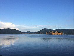
There is the Nahargarh Fort – the home of tigers, in these hills that provides a commanding view of the Man Sagar lake and the Jal Mahal palace, in addition to a beautiful view of the city of Jaipur. The lake was created by constructing a dam across the Darbhawati River, between Khilagarh hills and hilly areas of Nahargarh, in the 16th century. The drainage area of the lake is 23.5 square kilometres (9.1 sq mi)contributed by an urban area accounting for 50%, hilly terrain accounting for the balance area comprising the degraded Aravalli hills, which have added to siltation problem in the lake. Rainfall of an average of 657.4 mm (25.88 in) per year (90% of this rainfall occurs during the months of June to September) in the catchment contributes to the storage in the reservoir.
At the outlet end of the dam, there is an irrigation system that is supplied with water stored in the reservoir (obligatory water demand for this is reported to be 2,410,000 cubic metres during the five months from November to March). But two large nalas (streams) that also drain the surrounding Nahargarh hills and the Jaipur town are the Brahmpuri and Nagtalai, which bring in large amount of untreated sewage flows, in addition to solid wastes.
The hills surrounding the lake area, towards the north east of Jaipur, has quartzite rock formations (with thin layer of soil cover), which is part of Aravalli hills range. Rock exposures on the ground surface in some parts of the project area have also been utilised for constructing buildings. On the north east, the Kanak Vrindavan valley, where temple complex is situated, the hills slope gently towards the lake edge. Within the lake area, ground conditions depict a thick mantle of soil, blown sand and alluvium. Forest denudation, particularly of hilly areas, has caused soil erosion, compounded by erosion due to wind and water. Due to this, silt moved to the lake resulting in raise of the bed level of the lake.