KHARDUNG LA Ladakh, Jammu and Kashmir 194101, India
Khardung La is a high mountain pass located in Ladakh region of the Indian state of Jammu and Kashmir. The local pronunciation is “Khardong La” or “Khardzong La,” but, as with most names in Ladakh, the romanised spelling varies.The pass on the Ladakh Range lies north of Leh and is the gateway to the Shyok and Nubra valleys.
The Siachen Glacier lies partway up the latter valley. Built in 1976, it was opened to motor vehicles in 1988 and has since seen many automobile, motorbike and mountain biking expeditions. Maintained by the Border Roads Organisation, the pass is strategically important to India as it is used to carry supplies to the Siachen Glacier.
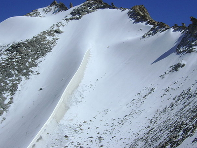
Local summit signs claim that its elevation is 5,602 m (18,379 ft) metres high and that it is the world’s highest motorable pass. But these claims are disputed by multiple modern measurements, which all agree that its true height is much nearer to the 5,359 m (17,582 ft) measured using DGPS and imply that there are several higher motorable passes.Khardong La is historically important as it lies on the major caravan route from Leh to Kashgar in Central Asia. About 10,000 horses and camels used to take the route annually, and a small population of Bactrian camels can still be seen at Hunder, in the area north of the pass. During World War II there was an attempt to transfer war material to China through this route.
Location:
Khardung La is situated 39 km by road from Leh. The first 24 km, as far as the South Pullu check point, are paved. From there to the North Pullu check point about 15 km beyond the pass the roadway is primarily loose rock, dirt, and occasional rivulets of snow melt. However, this pass is in better repair than many of the surrounding passes (Tanglang La, for example). From North Pullu into the Nubra Valley, the road is very well maintained (except in a very few places where washouts or falling rock occur). Hired vehicles (2 and 4-wheel-drive), heavy trucks, and motorcycles regularly travel into the Nubra Valley, though special permits may need to be arranged for travellers to make the journey.
Elevation:
The 5,359 m (17,582 ft) elevation measure was taken from a modern GPS survey by a team of researchers. It accurately matches SRTM data, ASTER GDEM data and Russian topographic mapping, and it is broadly consistent with several other independent travellers’ GPS reports and an article by Bonington.Several of these sources contain assertions by local people who claim that the 5,602 m (18,380 feet) height claimed by the summit signs has been inflated for the purpose of record breaking. The even higher elevation of 5,682 m (18,640 feet) that has been claimed by Guinness World Records and the National Geographic Society is not supported by any evidence and may be rooted in a copying error from 5,602 m.
Access:
The nearest town is Leh, the capital of Ladakh. Leh is connected by road from Manali and Srinagar, and daily flights are operated from Delhi. From Leh, a daily bus service to Nubra Valley passes over Khardungla. The ideal method to get to Khardung-la is by taxi or bike. Taking an experienced driver with you is advisable. The two bases on either side of Khardong-la are North Pullu and South Pullu. Inner Line Permit (ILP) is not needed to reach Khardung La peak, however Inner Line Permit is needed to cross North Pullu to reach Nubra Valley. Inner line permit can be procured at the DC’s office in Leh. Travelers are required to check in and must provide photocopies of the permits, to be deposited at each checkpoint. Altitude sickness is a serious health concern for travellers not previously acclimatized to high altitudes.
Prophylactic altitude-sickness medication like acetazolamide may be necessary for some travellers as there are no emergency medical facilities to treat altitude sickness along the route. The road is closed annually from approximately October to May due to snow and one should anticipate potential long travel delays due to traffic congestion on narrow one-lane sections, washouts, landslides and road accidents. As of 2007 a shared-taxi 4×2 jeep ride for the entire 22 hour road rest stops along the way are well stocked with food and water and offer inexpensive basic accommodations as well.